


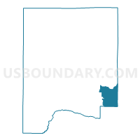
Grimes, Dale County, Alabama
About
Outline

Summary
| Unique Area Identifier | 521644 |
| Name | Grimes |
| County | Dale County |
| State | Alabama |
| Area (square miles) | 15.89 |
| Land Area (square miles) | 15.89 |
| Water Area (square miles) | 0.01 |
| % of Land Area | 99.97 |
| % of Water Area | 0.03 |
| Latitude of the Internal Point | 31.31454400 |
| Longtitude of the Internal Point | -85.44471300 |
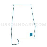
Maps

Graphs
Select a template below for downloading or customizing gragh for Grimes, Dale County, Alabama


Neighbors
Neighoring Voting District (by Name) Neighboring Voting District on the Map
- Headland Armory, Henry County, AL
- Library, Houston County, AL
- Midland City, Dale County, AL
- Sylvan Grove, Dale County, AL
- Vaughn Blumberg Center, Houston County, AL
- Westgate Recreational Center, Houston County, AL
Top 10 Neighboring County Subdivision (by Population) Neighboring County Subdivision on the Map
- Dothan CCD, Houston County, AL (84,863)
- Newton-Midland City CCD, Dale County, AL (9,526)
- Headland-Newville CCD, Henry County, AL (7,793)
Top 10 Neighboring Place (by Population) Neighboring Place on the Map
- Dothan city, AL (65,496)
- Midland City town, AL (2,344)
- Grimes town, AL (558)
- Napier Field town, AL (354)
Top 10 Neighboring Unified School District (by Population) Neighboring Unified School District on the Map
- Dothan City School District, AL (65,496)
- Houston County School District, AL (36,943)
- Henry County School District, AL (17,297)
- Dale County School District, AL (15,572)
Top 10 Neighboring State Legislative District Lower Chamber (by Population) Neighboring State Legislative District Lower Chamber on the Map
Top 10 Neighboring State Legislative District Upper Chamber (by Population) Neighboring State Legislative District Upper Chamber on the Map
- State Senate District 29, AL (136,679)
- State Senate District 28, AL (131,368)
- State Senate District 31, AL (129,622)
Top 10 Neighboring 111th Congressional District (by Population) Neighboring 111th Congressional District on the Map
Top 10 Neighboring Census Tract (by Population) Neighboring Census Tract on the Map
- Census Tract 402.02, Houston County, AL (8,142)
- Census Tract 305, Henry County, AL (5,951)
- Census Tract 214, Dale County, AL (5,492)
- Census Tract 415, Houston County, AL (4,173)
- Census Tract 213, Dale County, AL (4,034)
- Census Tract 403.02, Houston County, AL (3,589)